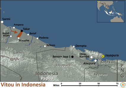
The Vitou people speak the Vitou language, a Papuan (non-Austronesian) language of the Foja Range/Tor–Kwerba family, spoken in inland areas of the northern coast of Papua Province (inland from Takar village in the Pantar Timur sub-district, Sarmi Regency).
The language is very small-speaker and moribund, mainly spoken by older adults.
Historically the Vitou have lived in remote interior forested regions of West New Guinea (the Indonesian province of Papua), with limited contact from lowland coastal trade or colonial infrastructure. The remoteness of their settlement has contributed to their linguistic isolation and small population.
The Vitou people live in remote, forested interior areas of Sarmi Regency, where access is limited and infrastructure is minimal. Their livelihoods revolve around subsistence through forest gathering, hunting, small-scale shifting gardens, and possibly small riverside fishing where accessible. Because the language is endangered and many younger people shift to Papuan Malay or Indonesian for wider communication, the Vitou face cultural and linguistic pressure. The transport, health-care, and formal schooling services in their area are likely minimal or difficult to reach, reinforcing a lifestyle of geographic isolation and limited external engagement. Modern influences (logging, migration, mission contact) may be slowly increasing, but much of their life remains shaped by a traditional forest-edge existence.
Detailed information on the Vitou people's religious beliefs is very scarce. In the broader northern Papua context many tribes have experienced missionary activity and are Christian (particularly Protestant) though some inland groups remain animist or practice syncretic traditions alongside introduced Christianity. Given the very small size and remoteness of the Vitou, it is plausible that their traditional belief systems — centered on ancestral spirits, forest-and-river cosmology and customary ritual — remain strong, perhaps with some mission influence entering but without large numbers of believers in Christ documented. Without verified data it must be noted that the Vitou likely remain a largely unreached people group from an evangelical standpoint.
The Vitou community would benefit greatly from language documentation, preservation and development of literacy in Vitou to help pass their mother-tongue and cultural heritage to younger generations before it is lost. Improved access to culturally appropriate education and transport infrastructure would help children and youth in Vitou villages to gain opportunities beyond subsistence and reduce isolation. Sensitive and respectful gospel engagement in the Vitou heart-language and culture would help bridge the gap between traditional belief systems and the message of Christ, enabling sustainable church-planting rather than external?parachute ministries.
Pray that the hearts of Vitou elders and families might become open to the work of the Holy Spirit, even in their remote forest setting, so that the gospel of Jesus Christ may take root.
Pray that God would raise up workers—especially indigenous Papua believers—who have skill in the Vitou language and culture and are willing to engage patiently and respectfully with this people group.
Pray for the development of Scripture portions, audio-visual discipleship tools or oral Bible stories in the Vitou language, so that the message of Christ is heard in their mother tongue with clarity and relevance.
Pray that as infrastructure, education and health services gradually reach Vitou villages, the church-workers would be able to accompany this holistic transformation in ways that honor Vitou identity and bring spiritual as well as physical flourishing.
Scripture Prayers for the Vitou in Indonesia.
Wikipedia, "Vitou language".
Insight Papua, "326 Languages in West Papua".
insightpapua.com
"Language shift threatens indigenous tongues in Papua, experts warn". Jubi/West Papua Daily.
| Profile Source: Joshua Project |


